Author: James Wilkinson
-
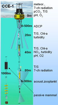
Sta 80.0 80.0
CalCOFI Station 80.80: lat 33° 29.0′ N lon -122° 32.0′ W (33.48333 -122.53335) is one of the primary station occupied on CalCOFI quarterly hydrographic survey cruises for over 70yrs. In March 06, 2011, a mooring (CCE-1) was deployed on sta 80.80. Real-time data can be viewed in the data section, and the sensor layout is…
-
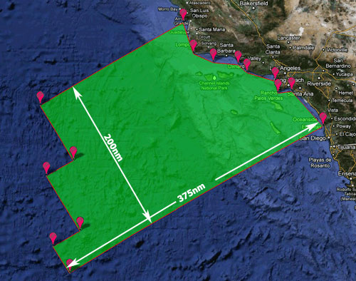
CalCOFI Working Area
CalCOFI’s sampling area has evolved over the 65 years of the program. The 66 standard station pattern in the Southern California Bight (SCB) has the best coverage since 1949. The current 75 station pattern, 66 standard + 9 SCCOOS 20m stations, was implemented in 2004. Refer to the Station Positions web page for coordinates for…
-
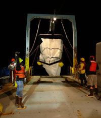
Matsuda-Oozeki-Hu Trawl
The Matsuda-Oozeki-Hu trawl (MOHT) is a fixed-frame trawl with a 5.5 m2 mouth opening with a cambered V-type depressor that can be towed at speeds up to 4.5 knots. It is designed to capture a variety of organisms including krill, late larval and juvenile fishes, and micronekton. The Oozeki data are used to groundtruth the…
-

PRPOOS Net
A Planktonic Rate Processes in Oligotrophic Ocean Systems (PRPOOS) net, formerly known as the Soutar-Hemingway Animal Trap or “SHAT” (Kramer 1972), is a 202 µm mesh net that has a 50 cm diameter single frame opening and is 3 m in length. The PRPOOS net deployment is a vertical tow lowered into the water to…
-
Pairovet Net
A Pairovet vertical plankton tow is performed at all stations inshore of, and including station 70. The Pairovet net fishes from 70 meters to the surface (depth permitting) using paired 25 cm diameter 150 um mesh nets. The technical requirements for Pairovet tows are: Descent rate of 70 meters per minute, ascent rate of 70…
-
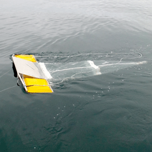
Manta Net
The twin winged continuous-flow surface tow, referred to as MT in the CalCOFI database, samples ~8cm of the ocean surface, minimizing wake disturbance from the ship. The MANTA Net is an improved design from the Neuston Net and is capable of continuous-flow collection of organisms at the ocean surface.
-
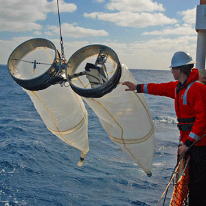
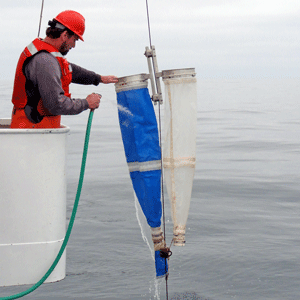
Bongo (CalBOBL) Net
Southwest Fisheries Science Center collects CalBOBL net tow samples for all CalCOFI and SCCOOS stations. The CalBOBL (Bongo) net, referred to as CB in the CalCOFI database, has been the standard sampler since replacing the CAL1MOBL in 1978. The net frame is connected to a central yoke which is swivel-shackled to the winch tow cable.…
-
Zooplankton
CalCOFI tows several net during cruises: Bongo Net (NOAA, all cruises, all stations); main source of zooplankton volume data Manta Net (NOAA, all cruises, all stations); neuston samples Pairovet Net (NOAA, all cruises, stations out to sta 60); fish eggs & larvae data PRPOOS Net (LTER, all cruises, cardinal LTER stations, Line 80); LTER zooplankton…
-
Underway Information
Underway data are continuous data collected while transiting between stations on CalCOFI cruises. Data collection usually continues while on station so there may be a few to several hours of data in a limited area. Processed underway data are 10 minute average, CTD or bottle sample corrected data. Different vessels such as NOAA RV Bell…
-
NOAA SCS Variables
CalCOFI cruises collect underway data on NOAA vessels from the SCS (Shipboard Computer System). These data may or may not be combined into a common, comma-delimited, ascii file. Most sensor data are collected at different frequencies and require post-cruise processing to combine into a standard time frame. RV New Horizon’s underway dataset may be a…