Author: James Wilkinson
-
Station Positions
The station transects and offshore stations are 40nm apart with coastal stations ~20nm apart. Current station numbering includes a decimal value to distinguish SCCOOS stations from standard CalCOFI stations; sta 93.3 26.7 (standard CalCOFI station) & 93.3 26.4 (SCCOOS), for example. Prior to 2004, standard CalCOFI station may be referenced by the integer line.sta number…
-
2013 Underway Data and Figures
January 10 – February 2, 2013 (RV Bell M. Shimada 1301SH) Data: Underway Raw Data Disk#1 Disk#2 Disk#3 • Underway Final Data • CTD • Regressions • Notes Temperature Cruise Path PDF • PNG Salinity Cruise Path PDF • PNG Chlorophyll Cruise Path PDF • PNG April 6 – April 30, 2013 (RV Bell M. Shimada 1304SH) Data: Underway Raw Data Disk#1 Disk#2 Disk#3 • Underway Final Data • CTD • Regressions • Notes…
-
Survey Coverage 1937 – 2019
CalCOFI Station Coverage since 1937 Maps depicting Ichthyoplankton cruises (1937 to 1941) and CalCOFI cruises (1949 to present) Cruises from 1937 through 1987 are adapted from Hewitt, R.P. 1988. Historical review of the oceanographic approach to fishery research. CalCOFI Report, Vol XXIX. Cruises from 1988 to present are drawn from published CalCOFI data reports…
-

CalCOFI Atlases
# Web Link Hits 1 Atlas 01 1963: CalCOFI 10-meter temperatures and salinities 1949-1959. Anonymous. 1963. CalCOFI atlas of 10-meter temperatures and salinities 1949-1959. 998 2 Atlas 02 1964: Distribution of calanoid copepods in the California Current region, Part I. Fleminger, A. 1964. Distributional atlas of calanoid copepods in the California Current region,…
-
Data Usage and Distribution Policy
CalCOFI hydrographic and plankton data are distributed to the community for use without restriction. Unless otherwise noted, these data can be considered final data which have been evaluated using CalCOFI data quality control procedures. Methods for data collection and processing are summarized in each cruise’s Data Report Introduction. To see the methods used on specific cruises,…
-
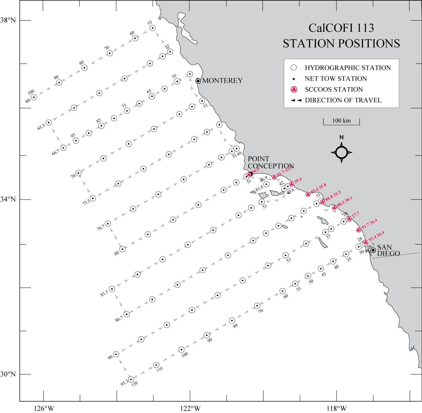
113 Station Pattern
During winter and spring, 113 stations have occasionally been occupied, weather & ship-time-permitting (25+ DAS). The 38 additional stations located north of Point Conception (lines 73.3 through 60.0) are surveyed but the ship may only stop when fish egg densities are high. Line 66.7, off Monterey, is part of the MBARI ‘SECRET’ time-series with stations…
-
75 Station Pattern
CalCOFI’s standard station pattern since 1984 includes 66 stations from San Diego to Pt Conception (Lines 93.3 to 76.7). Nine additional coastal ~20m SCCOOS stations were added July 2004. Thirty-eight additional stations off central and northern California are typically scheduled during winter and spring cruises, time and weather-permitting (Lines 73.3 to 60.0). A 73 station pattern…
-
Volunteering
Volunteers on CalCOFI Interested in participating in an oceanographic cruise? Two volunteers are recruited for each cruise to help CalCOFI personnel deploy equipment, collect data, and draw/analyze seawater samples. General Criteria for Applicants: Sea-worthiness (experience at sea, recreational is acceptable) Good health; able to lift 50lbs Scientific background (must have completed at least two…
-
2013 CalCOFI Conference
The 2013 CalCOFI Conference was held in the NOAA Fisheries Southwest Fisheries Science Center on the Scripps Institution of Oceanography Campus, in La Jolla, CA, 9-11 December, 2013 ( Map ). Thanks to all presenters and attendees for making it such a great success. The Symposium of the Conference: Forage species and assemblages in the…